Discount Products: Look through products available for a 25% – 50% discount in 2020. The items provided on a first come, first serve basis. View Discounted Products
Sensofar SensoVIEWPowerful Analysis Software
- Powerful Analysis Software
- 3D exportable in multiple formats
- Simple yet powerful, designed for you
- Smart calculations tool for key parameters
- The most perceptive visualization of your topographies
- Customizable reports for more flexible results presentations
Introducing the Sensofar SensoVIEWPowerful Analysis Software
SensoVIEW is the ideal analysis software for a broad range of analysis tasks. It includes a comprehensive suite of tools for preliminary examination and analysis of 3D or 2D measurements, allowing roughness or volume calculations and measuring critical dimensions (angles, distances, diameters) with a set of analysis tools.
SEQUENTIAL OPERATORS
Guided measurement examination
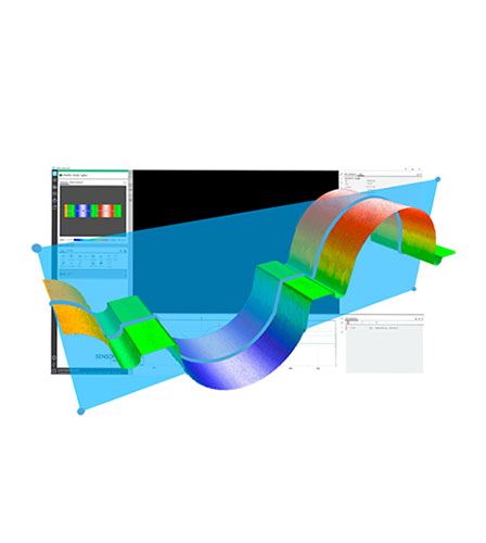
A smart suite of operators, which can be applied to 3D/2D measurements and profiles, provides the opportunity to remove form, apply a threshold, retouch data points, restore non-measurable data and apply a range of filters and/or generate alternative layers by cropping, subtracting or extracting a profile, to prepare your data analysis.
Form removal
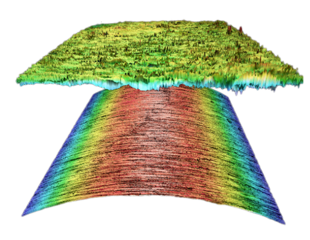
The form removal SensoVIEW’s operator is used for samples that need to be leveled due to a tilt (linear form), an inherent spherical or cylindrical component, or that exhibit or possess an unwanted polynomial term. Several options are available: plane, main slope, cylinder, sphere or polynomial degree.
Key Features
EASY TO USE
Simple yet powerful, designed for you
This dynamic software provided with the Sensofar systems offers a complete set of user friendly tools for displaying and analyzing measurements. The user is trained and guided through the 3D environment, delivering a unique user experience: Access to operators in just one-click; icons with eye-catching design; a better function understanding; and simultaneous 3D, 2D and profile views are just some of the key features of the SensoVIEW analysis software.
ISO PARAMETERS
Smart calculations tool for key parameters
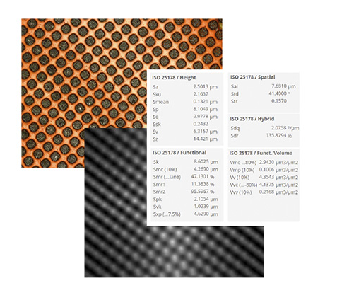
SensoVIEW analysis software provides a specific step-guide to get surface texture parameters according to ISO 4287 and 25178 with just one click. It is the easiest way to fulfill with roughness & waviness ISO standards, simplifying the process of analyzing the measurement data.
3D exportable in multiple formats
Several options are available for managing the output files. When saving a measurement in SensoVIEW analysis software, the raw data is always preserved. The measurement surface data can be exported in *.dat, *.stl, *.pcl, and *.x3p formats.
Customizable reports for more flexible results presentations
With the possibility to choose from different report templates, the user can configure every section to fit as much as possible to their requirements. A flexible way to obtain clear and well-structured reports for each measurement, showing the acquisition information, 3D data, a 2D profile and all the ISO parameters, among others.
The most perceptive visualization of your topographies
mage control options are always in continuous development for an excellent fit to all sample types and customer needs. A full range of image processing settings are included in each of the rendering visualizations choices and presented together with scale options for a better adjustment.
Surface texture characterization
The ISO 25178: Geometric Product Specifications (GPS) – Surface texture: areal standard is an International Organization for Standardization collection of international standards relating to the analysis of 3D areal surface texture. It is the first international standard that takes into account the specification and measurement of 3D surface texture, and in particular defines 3D surface texture parameters and the associated specification operators.
Key Benefits
Useful assist measurement tools
Assist tools are a quick and handy way to draw the most basic and primary forms (points, lines and circles) in selected rendering views to, later on, add the corresponding dimensions. It is an optional aid when drawing the measurement tools.
Multiple measurement tools
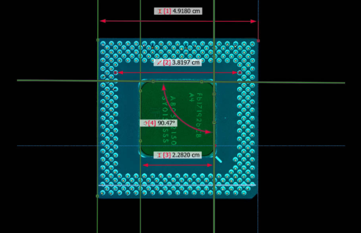
A complete assortment of tools ready to add the most essential dimensions when measuring critical dimensions (radiuses, angles, diameters, step heights and perpendicular & parallel distances). These tools will return a numerical value for a particular dimension.
Trust the Experts at Spectra Research Corporation
Spectra Research Corporation (SRC) offers a range of innovative high-quality scientific products and laboratory services to industrial and scientific markets throughout Canada.
Specifications
XYZ CALCULATIONS
Measuring critical dimensions in all axes
Always with the priority of facilitating operations and procedures for the user, assist tools have been developed for critical dimension options. With SensoVIEW, critical dimensions such as angles, distances, diameters can be easily measured and highlight features with a measurements tool.
3D CALCULATIONS
Volume geometries
Volume calculation allows the user to get the volume of a 3D topography region. Two modes are possible: thresholding (defining the minimum and maximum Z limits) or leveling (defining a ROI by circle, polygonal or rectangular geometries).
2D CALCULATIONS
Measuring critical dimensions
Measuring specific features like points, distances, radiuses, diameters or angles on a 3D topography measurement, a 2D profile measurement, a profile of a 2D section through a 3D measurement and even on the histogram of a 3D measurement.


